
 Facebook
 X
X
 Pinterest
 Copy Link

Spring is officially here, so let’s get outdoors and stretch our legs after a long winter spent inside. The DMV offers a diversity of trails and parks to explore. Some are maintained by county, city, or state governments while others are part of the National Park Service. So grab your camera and binoculars and share your adventures with family and friends.
If you do decide to hike trails that are part of the National Park Service, you can visit their website for more information on Current Conditions in the National Capital Area parks.
A great resource for discovering new trails, the popular website All Trails also has an app for your phone which will help you stay on track when exploring — and with off-route notifications, you’ll never miss a turn. No cell service? No problem. Download offline maps or print a backup copy.
WASHINGTON, D.C.
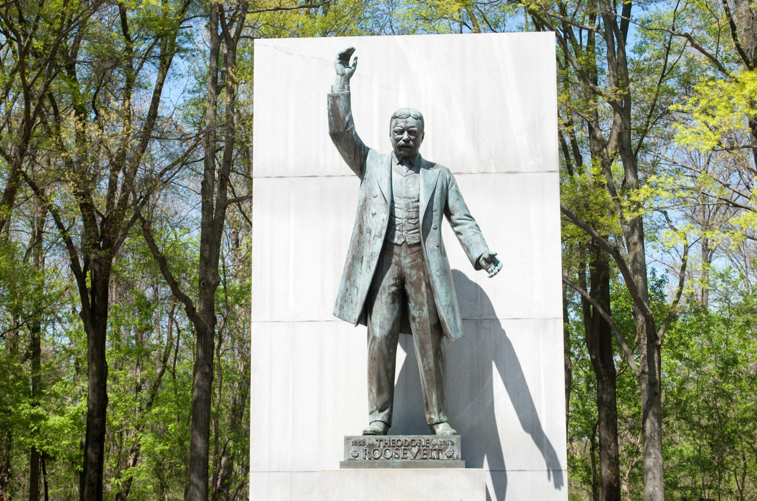
Theodore Roosevelt Island
Trail Map | Directions | Facebook
In the 1930s, Mason’s Island was transformed into a living memorial to America’s 26th president. Today miles of trails through wooded uplands and swampy bottomlands draw hikers to Theodore Roosevelt Island. Park is accessed from the Virginia side of the Potomac River along the GW Memorial Parkway.
Rock Creek Park
Trail Map | Directions | Facebook
This 1,754-acre city park was officially authorized in 1890, making it the third national park to be designated by the federal government. It offers visitors the opportunity to escape the bustle of the city and find a peaceful refuge, recreation, fresh air, majestic trees, and wild animals. Some roads are closed on the weekends for the enjoyment of park visitors. Along with two main trails, which are primarily used for hiking, walking, and nature trips, there are playgrounds, sports fields, and historic sites. Dogs are allowed on trails, but must be kept on leash.
- Western Ridge Trail – 8.9 miles/moderate
- Valley Trail – 10.8 miles/moderate
- Boulder Bridge Loop – 3 miles/easy
Glover-Archbold Trail
Trail Map | Directions | Facebook
Although not directly adjacent, Glover-Archbold Park is part of Rock Creek Park, along with Meridian Hill Park and Dumbarton Oaks Park. Easily accessible, the Glover-Archbold Trail is a great spot for picnicking and running. 5.7 miles/easy
Anacostia Riverwalk Trail
Trail Map | Directions | Facebook
Explore 3.5 miles of paved trail in Anacostia Park! The Anacostia Riverwalk Trail is great for a casual stroll, a jog, a bike ride, or a dog walk. Along the way, you’ll experience views of the Anacostia River and its wildlife, or maybe join a pick-up game on one of the playing fields or courts. The paved walkway continues across the bridges into downtown D.C. with access to the Navy Yard and Capitol Hill neighborhoods.
Capital Crescent Trail – DC & Maryland
Trail Map | Directions | Facebook
The Capital Crescent Trail (CCT) is a rail-trail, built upon the former railbed of the 11 mile Georgetown Branch of the B&O Railroad. The Trail is complete as a hard surface asphalt trail from Georgetown to Bethesda, with 6 bridges and a tunnel offering users gentle gradients, with grade-separated crossings at most (all but 2) roadways.
MARYLAND
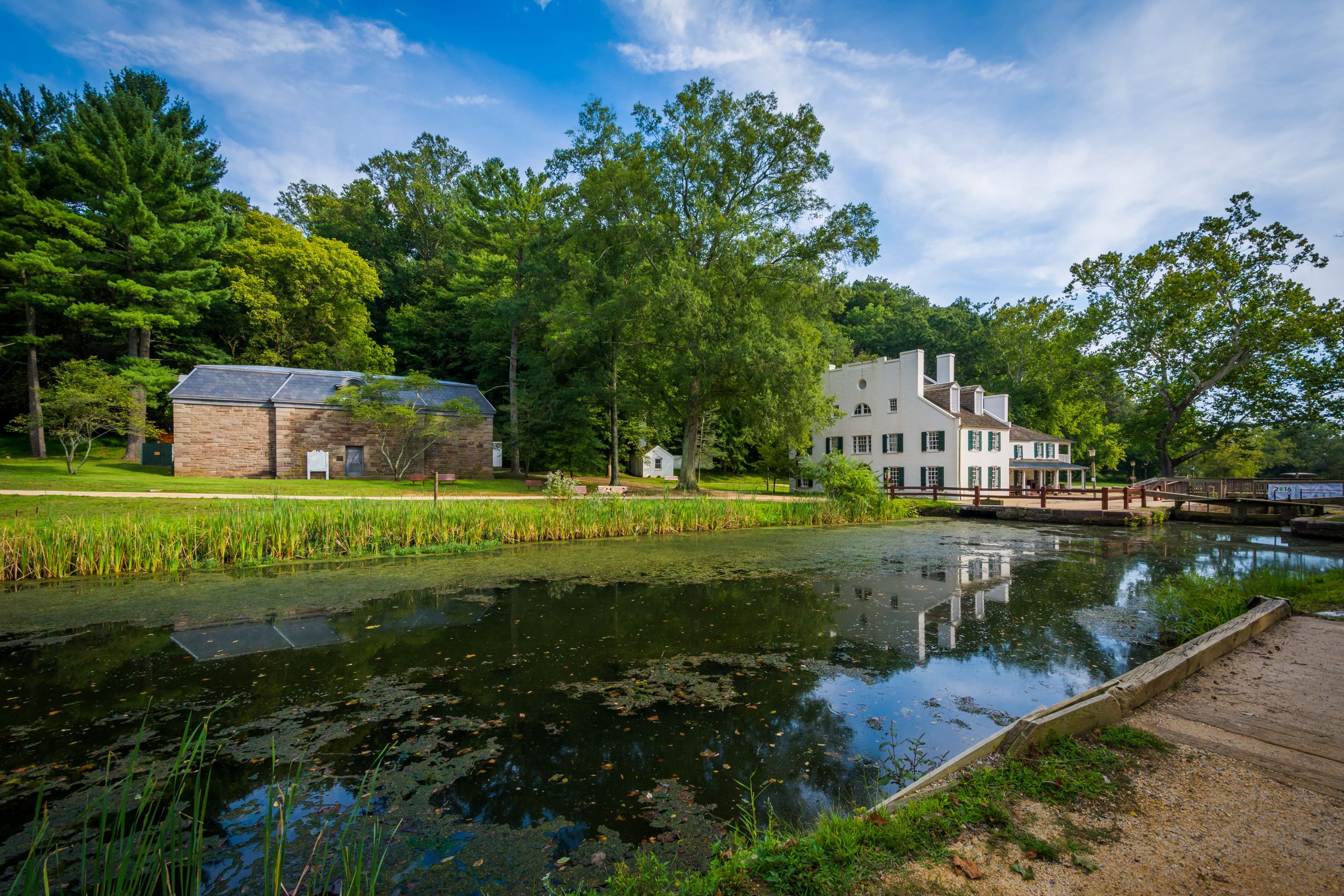
Chesapeake & Ohio Canal at Great Falls
Trail Map | Directions | Facebook
The C&O Canal operated for nearly 100 years along 184.5 miles of the Potomac river. On the Maryland side of Great Falls, there are more than half a dozen trails and paths. Section A of the Billy Goat Trail, one of the most popular in the DC area, offers a more challenging hike.
Greenbelt Park – Greenbelt
Trail Map | Directions | Facebook
With more than nine miles of trails, this park is also Metro accessible! Also a popular site for bird watching and affordable camping only 12 miles from DC.
VIRGINIA
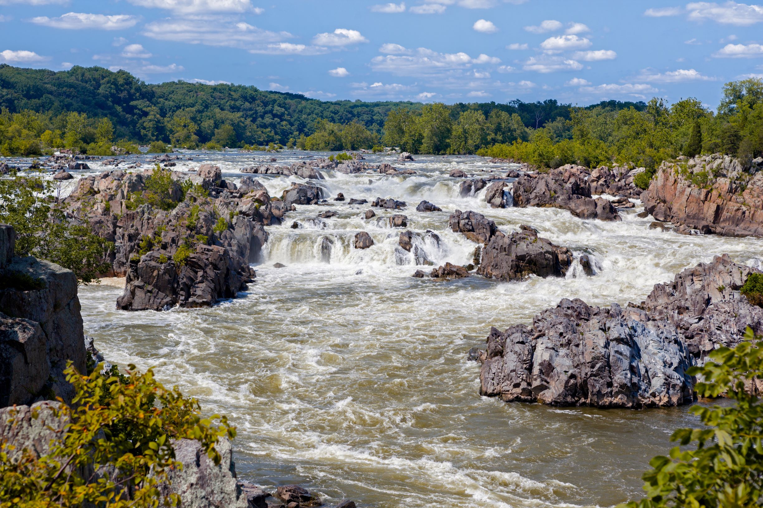
Great Falls Park – McLean
Trail Map | Facebook | Instagram
At Great Falls, the Potomac River builds up speed and force as it falls over a series of steep, jagged rocks and flows through the narrow Mather Gorge. The park offers many opportunities to explore history and nature, all in a beautiful 800-acre park only 15 miles from Washington, DC. Trail lengths range from 1.8-3.2 miles.
Scott’s Run Nature Preserve – McLean
Trail Map | Directions | Facebook
Scott’s Run Nature Preserve is part of the Potomac Gorge and offers a variety of opportunities from gentle trails that wind quietly through the forest to others that require hiking up and down precipitously steep hills and cliffs. The rugged terrain is part of the park’s charm.
Mount Vernon District Park – Alexandria
Trail Map | Directions | Facebook
Mount Vernon District Park is a 1.5 mile moderately trafficked loop trail located in Belle View. The trail is primarily used for hiking, walking, and mountain biking and is good for all skill levels. Dogs are also able to use this trail.
Mount Vernon Trail – Alexandria
Trail Map | Directions | Facebook
Winding along the Potomac River, the Mount Vernon Trail is an 18-mile paved, multi-use trail that stretches from George Washington’s Mount Vernon Estate to Theodore Roosevelt Island. It connects with regional trails, including the Potomac Heritage, Custis, Rock Creek, Four Mile Run, and Woodrow Wilson Bridge Trails. Popular with runners, walkers, and cyclists, the skyline views of Washington, DC are beautiful.
Jones Point Park – Alexandria
Trail Map | Directions | Facebook
Looking for a short, easy walk in a beautiful setting? Try Jones Point Park located on the Potomac River, just south of Old Town. It was a critical piece of the city of Alexandria’s history as one of the largest centers for shipping, manufacturing, and transportation in the nation. Its lighthouse, built in 1855, is the last remaining riverine lighthouse in Virginia.
Four Mile Run Trail – Arlington
Trail Map | Directions | Facebook
Four Mile Run Trail traverses the Four Mile Run stream valley and has many twists and turns, not to mention steep sections (mercifully short). The trail more or less parallels the popular W&OD Trail, connecting to it in several places. At 15.2 miles, this heavily trafficked, out and back trail is primarily used for walking, running, and road biking. Dogs are also able to use this trail but must be kept on leash.
Meadowlark Connector Trail – Vienna
Trail Map | Directions | Facebook | Instagram
Only 1.25 miles long, this is a paved trail that leaves from Meadowlark Botanical Gardens and gets to the W&OD Trail. About half of this trail is on a path and the other half on the road. But, you can spend the day checking out the gardens and also get in a great hike. In fact, take as long a hike as you want.
Bull Run Regional Park – Centreville
Trail Map | Directions | Facebook
There are three trails in this 1,500-acre Northern Virginia Park and a variety of other activities to get you outdoors including camping, cabin rentals, picnic areas, even a waterpark. The miles of scenic and historic trails are perfect for hiking and horseback riding.
- Bull Run Occoquan Trail – 19.7 miles
- Bluebell Trail – 1.5 miles
- White Trail – 2.5 miles
Elizabeth Hartwell Mason Neck – Lorton
Trail Map | Directions | Facebook
In the early 1960s a developer sought out land on Mason Neck to build a planned community and airport. Elizabeth van Laer Speer Hartwell, a local resident, who valued the pristine nature of the peninsula, organized an effort to stop this development. She recognized the potential of the Mason Neck peninsula as a safe haven for the endangered bald eagles along the Potomac River. The Woodmarsh Trail is a 3-mile circuit through mature forest with a sweeping view of the 250-acre Great Marsh.
Banshee Reeks Nature Preserve – Leesburg
Trail Map | Directions | Facebook
Banshee Reeks is a Loudoun County nature preserve which ensures that plants, animals, habitats and cultural resources are protected. There are 20 miles of well-marked trails to explore on 695 acres including Goose Creek, wetlands, grass trails, open fields, wooded areas, and mountain views.
W&OD Trail – Purcellville to Arlington
Trail Map – Print PDF | Directions | Facebook
Often called the skinniest park in Virginia, Washington & Old Dominion (W&OD) Railroad Regional Park is a paved trail between Purcellville and Shirlington along the former railroad roadbed. While many people are searching for peace and quiet, you can also start the 45-mile trail in the countryside and head into the suburban and urban centers. Equestrians can ride the adjacent 32-mile gravel horse trail. The W&OD trail has multiple parking areas, enabling you to jump on and off the trail at various points.
Don’t miss a post! Get the latest local guides and neighborhood news straight to your inbox!
![]()


